Wednesday, May 1, 2024
By: Isabella Guttuso Browne & Tatiana Rodriguez
The University of Florida’s Center for Landscape Conservation Planning (CLCP) and GeoPlan Center have developed two new tools to support land protection decisions in Florida – a web map viewer and web-based dashboard for the Florida Ecological Greenways Network (FEGN).
The FEGN is a statewide database that identifies and prioritizes a functionally connected statewide ecological network of public and private conservation lands. The CLCP is the lead entity maintaining this database, which provides the science foundation and boundaries for the Florida Wildlife Corridor.
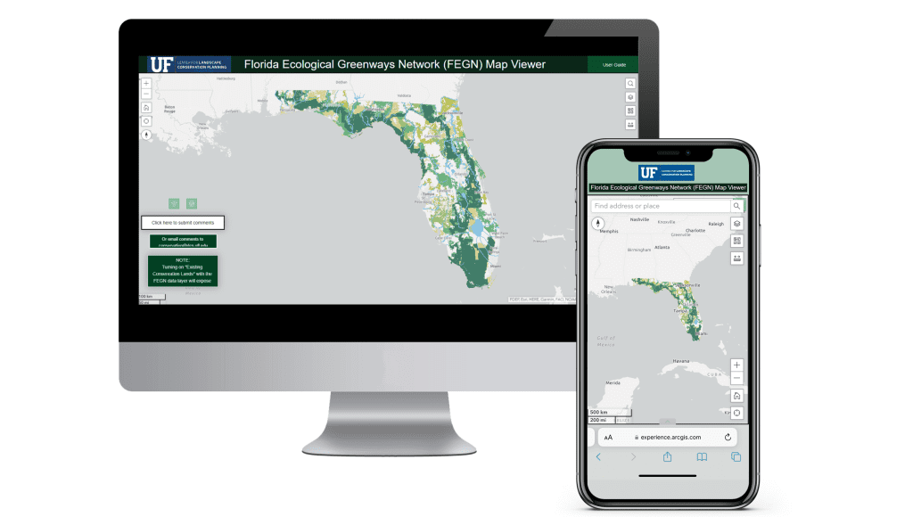
The FEGN map viewer is designed to make the Florida Ecological Greenways Network easier to explore. It includes information about existing and proposed conservation lands, future development scenarios, political boundaries, sea level rise projections, and more. “The viewer also highlights opportunity areas for protection within the FEGN, and will be useful to government officials, land conservation planning professionals or interested citizens – with the ultimate goal of better supporting data-driven and strategic decisions for land protection in Florida.”
“We have amazing tools and information that have been out for a very long time, but especially in this digital day and age, the goal is to make this information more accessible and digestible,” said Isabella Guttuso Browne, the CLCP’s Urban and Recreational Green Infrastructure Coordinator.
“We hope these tools will help publicize the FEGN and highlight some of the threats it faces,” said Mike O’Brien, GIS Manager for the CLCP who helped develop the GIS data for the viewer. “Greenfield development is probably the biggest threat to the Network, especially in central Florida. The viewer and dashboard show that land-use decisions made over the next few decades will determine whether the state’s natural areas are connected or isolated.”
“We also recognize how important it is to make this information as accessible and user-friendly as possible, so anyone interested in exploring our state’s ecological connections, priorities, and threats can do so,” added Sarah Lockhart, the CLCP’s Networking and Communications Analyst who helped develop the layout, user guide, and video aspects of the tool.

The web-based dashboard that the CLCP launched focuses on the opportunities and threats associated with the FEGN at various scales. Its initial view displays projected development through the year 2070 at a statewide scale. Users can also select a specific county or political district to view the FEGN in conjunction with development trend statistics for that area. The dashboard also shows the counties where the FEGN is most and least protected and where development is projected to pose the greatest threat.
“The partnership between the GeoPlan Center and CLCP on this project has been very rewarding,” said Crystal Goodison, Associate Director of the GeoPlan Center and one of the primary GeoPlan staff assisting with development of the dashboard along with Erik Finlay, GIS Analyst. “Our intent for these dashboards and mapping tools is to create impactful visualizations that effectively communicate the implications of CLCP’s research. By making the data and statistics easily digestible to decision makers, planners, and the public, we hope to empower more protection of Florida’s unique and sensitive lands.”
The University of Florida’s Center for Landscape Conservation Planning and GeoPlan Center are currently coordinating to develop additional map viewers, dashboards and other tools for release in the coming year – with the goal of providing additional tools to support land conservation in Florida.
To learn more about the Florida Ecological Greenways Network, visit FEGN – Center for Landscape Conservation Planning (ufl.edu)
The FEGN Viewer is available here:
https://experience.arcgis.com/experience/27b8d8cd961c4f5091655c52c74d3ada
The FEGN Dashboard is available here:
https://ufl.maps.arcgis.com/apps/dashboards/0caf1487f546449899e2ceda01484a9b