
What is Urban Analytics?
Urban analytics incorporates data, spatial analysis, computing, visualization, and artificial intelligence to understand how cities function and to support better urban decision-making.
Study Complex Urban Systems
Use data to investigate patterns in mobility, land use, infrastructure, communities, and the built environment.
Build Technical Skills
Apply GIS, programming, data science, visualization, and machine learning to urban questions.
Support Urban Decisions
Translate analysis into evidence that can inform planning, policy, design, and public or private-sector decisions.
Why UF?
Urban planning expertise meets technical AI training.
Technical AI Coursework
Build AI and machine learning skills through technical courses in engineering, computing, and related fields.
Urban Context is Central
Address real urban challenges through planning coursework and a research project, with pathways tailored to your background.
Cross-department Learning
Learn from faculty across planning, engineering, computer science, and architecture.
Career Pathways
Urban analytics skills can support work in public agencies, consulting, planning and design firms, transportation, environmental planning, and data-focused roles.
Career Areas
- Urban Data & Analytics
- GIS & Geospatial Analysis
- Transportation & Mobility
- Planning & Policy Analytics
- Smart Cities & Urban Technology
- Data Science & AI
Job Titles
- Data Analyst
- City Planner
- Urban Designer
- Consultant
- Transportation Planner / Engineer
- Environmental Planner
Choose the Program That Fits Your Goals
UF currently offers both a full master’s degree and a graduate certificate in Urban Analytics.
M.S. in Urban Analytics
Designed to prepare students to use data, GIS, computing, visualization, and artificial intelligence to understand and address complex urban challenges.
Graduate Certificate in Urban Analytics
Designed for students across disciplines who want to strengthen their skills in urban data analysis, GIS, data science, and artificial intelligence.
What You’ll Learn
Build a balanced skill set that connects urban systems knowledge with spatial analysis, programming, visualization, and machine learning.
Urban Data & Analytics
Work with complex urban datasets and develop analytical approaches for interpreting patterns and change.
GIS & Spatial Analysis
Analyze, model, and visualize geographic patterns using geospatial methods and tools.
AI & Machine Learning
Apply machine learning and related computational methods to urban data and urban systems.
Urban Applications
Connect technical analysis with planning, transportation, land use, policy, and other urban applications.
Curriculum
Review the program structure here, then open the detailed course pages for course titles, credits, terms, policies, and model semester plans.
M.S. in Urban Analytics – 30 Credits
| Component | Credits | Overview |
|---|---|---|
| Required Core Courses | 18 | Urban data structures, planning foundations, introductory and intermediate urban analytics, and a 6-credit Master Research Project. |
| Elective Group 1: Urban and Regional Planning | 6 or 9 | Planning information systems, geospatial modeling, spatial analysis, transportation and land use modeling, and related urban methods. |
| Elective Group 2: Machine Learning | 6 or 9 | Machine learning, pattern recognition, intelligent systems, and related technical coursework across UF departments. |
| Total | 30 | The elective allocation depends on academic background and applicable waivers. |
Graduate Certificate – 15 Credits
Option A
9 credits of required core courses, plus 3 credits in Urban and Regional Planning Theory and Methods and 3 credits in Data and Computer Science.
Option B
6 credits of required core courses, plus 9 credits in Urban and Regional Planning Theory and Methods.
Student Research in Urban Analytics
Selected M.S. research shows how students apply urban analytics methods to questions in urban design, environment, housing, public finance, and transportation.

Land surface temperature clusters in New York City
GREEN SPACE AND URBAN HEAT
Exploring the Relationship Between Urban Green Spaces and Sociodemographic Variables with Urban Heat Island Effect in Major U.S. Cities
Mia L. J. Ciceri
Abstract:
With almost two-thirds of the world population expected to live in urban areas by the year 2050, rapid urbanization is a problem that many cities are having to deal with (United Nations, 2018). Certain issues have risen due to this such as housing crises, lack of resources, and a phenomenon known as Urban Heat Island (UHI) Effect. UHI is responsible for increased temperatures in urban areas that negatively affect the health of residents and the environment. Planners, developers, and governments are searching for ways to address UHI in ways that serve the ecosystem as well as those who live in rapidly urbanized communities. One method to achieve this is to understand the relationship that green infrastructure such as parks, plazas, and gardens has on temperature. Another approach is to analyze how sociodemographic variables related to race, education, and income help map UHI.
Generally, past research has shown that the presence of green infrastructure and organic matter decreases temperatures in cities. However, there are some exceptions to these findings, and the rate or strength of this effect varies wildly depending on the type of green infrastructure, physical configuration of green space, city structure, etc. There are many studies that explore this relationship in major cities in the world using data from remote sensing, light detection and ranging (LiDAR), satellite imagery, and more.
The purpose of this study is to examine the effect that green infrastructure, green spaces, and sociodemographics have on UHI in major U.S. cities. Major findings show that there is a significant relationship between green space, social and demographic variables, and UHI effect. However, this relationship varies amongst the different study areas, highlighting the necessity in localized decision-making and planning. The findings aim to describe an optimal framework to identify the best practices and methods for planners and designers to use to reduce the negative effects of UHI when faced with rapid urbanization in U.S. cities.

Illustration of market value and assessed value over time
PROPERTY TAXATION & EQUITY
Ryan Chisholm
Abstract:
Property taxation is the primary revenue source for local governments in Florida, but its distribution is heavily shaped by exemptions and assessment limitations that shift tax burdens across property owners. Policies such as Save Our Homes reduce tax liability for long-tenure homeowners while shifting a disproportionate share of the burden onto newer buyers, increasing barriers to homeownership and reducing housing mobility. This research evaluates how alternative property tax systems could redistribute these burdens while maintaining revenue neutrality.
Using parcel-level data from Pinellas County, four tax models were simulated: the current system, a land value tax (LVT), a progressive property tax modeled after Washington, D.C., and a full homestead exemption policy proposed by the state. Each model was calibrated to generate equivalent total revenue for each taxing district, allowing direct comparison of distributional outcomes.
Results show that the current system produces substantial tenure-based inequities, with recent homebuyers facing effective tax rates more than three times higher than long-tenure homeowners. The LVT produces the greatest improvements in equity but significantly increases homeowner tax burdens. The progressive system achieves comparable equity gains with more moderate impacts, while the full homeowner exemption-based approach shifts the highest burden onto rental and non-homesteaded properties.
Ultimately, the findings indicate that progressive rate structures offer the most balanced approach, improving tax equity without imposing large increases on homeowners, while exemption-based policies exacerbate burden shifting. These results demonstrate that observed disparities are not inevitable, but the result of policy design, and that more equitable property tax systems are achievable within revenue-neutral frameworks.

Median housing values across Florida census tracts
HOUSING AND SPATIAL ANALYSIS
Neighborhood Socioeconomic Conditions and Housing Values in Florida
Chi Zhang
Abstract:
This study examines how neighborhood socioeconomic conditions are related to housing values across census tracts in Florida. Using data from the 2018–2022 American Community Survey and 2020 TIGER/Line shapefiles, a dataset of 4,167 census tracts is constructed. The analysis combines descriptive statistics, spatial autocorrelation analysis, ordinary least squares (OLS) regression, and a Random Forest model. Results show clear spatial clustering in housing values, with a Global Moran’s I of 0.383, indicating strong positive spatial dependence.
Regression results suggest that median household income and higher education ratio are positively associated with housing values, while non-employment is negatively related. Vacancy rate and median age are also positively associated with housing values, which may reflect Florida’s unique housing market and demographic structure, including seasonal housing and a large retiree population.
The Random Forest results are consistent with the regression findings and confirm the importance of income as the main predictor. Overall, the study shows that housing values in Florida are shaped by both socioeconomic factors and state-specific demographic characteristics, highlighting the importance of considering local context in housing market analysis.
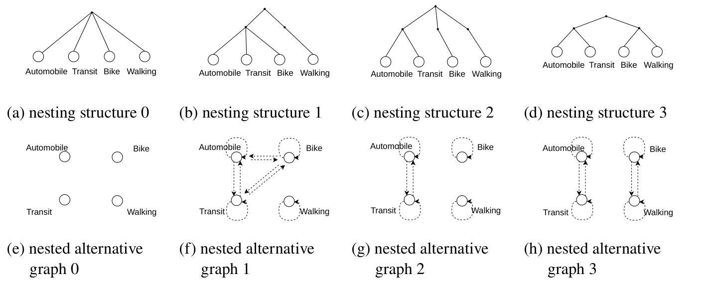
Nesting structures and their corresponding alternative graphs
MACHINE LEARNING AND TRANSPORTATION
Developing Alternative Graph Neural Networks to Generalize Nested Logit Models for Travel Mode Choice
Yuqi Zhou
Abstract:
Generalized extreme value models capture dependence among choice alternatives in discrete choice modeling, but require this dependence to be predefined, symmetric, and shared uniformly across individuals. Recent efforts to synergize discrete choice modeling with deep neural networks have improved predictive performance but still cannot explicitly represent alternative dependence within neural architectures. To address these gaps, we introduce the alternative graph – a graph in which nodes represent choice alternatives and edges encode their dependence -and propose Alternative Graph Neural Networks (Alt-GNNs), a family of GNN-based discrete choice models that embed alternative dependence within a unified framework. Theoretically, Alt-GNNs incorporate multinomial logit, nested logit, and deep neural network architecture with alternative-specific utility functions as special cases and enable innovative model designs, including Nested Alt-GNN, Complete Alt-GNN, and Attention Alt-GNN. Alt-GNNs are consistent with random utility maximization theory, enforce behavioral constraints through alternative graphs, and offer a novel graph-based interpretation of utility functions. Empirically, on two travel mode choice datasets from London and Chicago, Alt-GNNs significantly improve predictive performance over all benchmark models in mode choice modeling because of their flexible alternative graph design and vast hyperparameter space. Even the simplest Alt-GNN variable – Nested Alt-GNN – generalizes the nested logit model while preserving its unique two-layer substitution properties, enabling graph-based behavioral constraints over otherwise unconstrained behavioral patterns from deep neural networks. In addition, Alt-GNNs also enable graph-based, individualized, and asymmetric interpretation of alternative dependence, transcending pre-defined nesting structures dominant in GEV models. Overall, this study provides a unified graph neural network framework that synergizes classical GEV models with modern graph neural networks, advancing both predictive accuracy and behavioral interpretation in travel mode choice modeling.
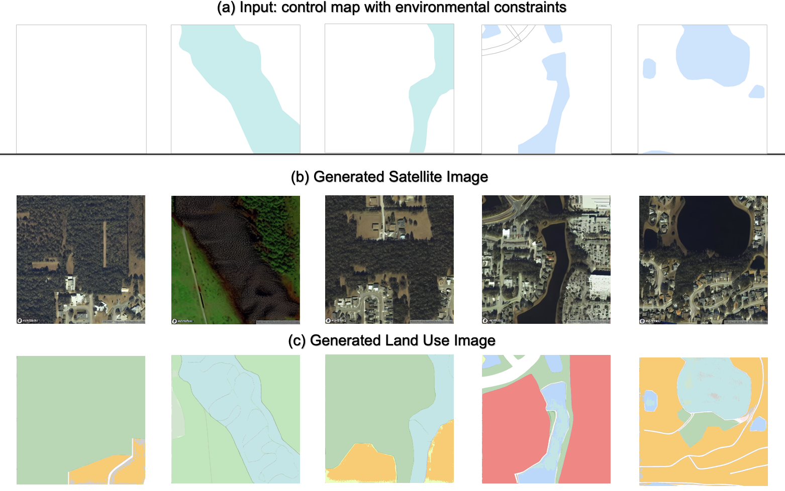
Synthetic satellite and land use images in Orlando
GENERATIVE AI & URBAN DESIGN
DualControlNet: A Multimodal Generative AI Framework for Jointly Synthesizing Land Use and Satellite Imagery
Qingqi Song
Abstract:
Researchers have adopted a wide range of tools to design urban systems. However, past studies rarely investigated how to use generative AI to create spatially consistent multimodal representations, which is a fundamental characteristic of any geospatial system. Here I introduce DualControlNet, a novel diffusion framework that jointly synthesizes high-resolution remote sensing and land use images, addressing the overlooked need for multimodal spatial generation. By adding a geospatial loss, I designed DualControlNet and compared it to the baseline diffusion models, evaluating their visual realism, spatial consistency, and prompt consistency using two data sets from Orlando and Chicago. Empirically, I found that DualControlNet enhances spatial consistency, raising cosine similarity by 8.4% over the state-of-the-art benchmarks. It also produces visually realistic and spatially accurate urban representations that adapt to various city contexts, with a 4.9% improvement in image realism and a 5.8% increase in density similarity. Generative experiments further demonstrate that DualControlNet consistently responds to the built environment metrics, assisting in exploring sustainable urban scenarios in a computationally efficient manner. Our findings highlight the potential of generative AI to bridge quantitative planning objectives and urban system designs, offering a scalable and interpretable tool for spatial analytics and scenario-based urban planning.
Admissions & Application
Review deadlines and expand the application requirements for the M.S. or Graduate Certificate.
MASTER OF SCIENCE
M.S. in Urban Analytics
Priority Application Deadlines
| Fall admission | January 15 |
| Spring admission | August 15 |
Applications submitted after the priority deadline may be considered on a case-by-case basis, subject to program policy.
Questions about your application?
Prof. Zhong-Ren Peng
Graduate Certificate
Graduate Certificate in Urban Analytics
Priority Application Deadlines
| Fall admission | March 1 |
| Spring admission | November 1 |
Applications are accepted on a rolling basis throughout the year.
Questions about your application?
Prof. Emre Tepe
Faculty & Research
Explore the Urban and Regional Planning faculty profiles below. The Electrical and Computer Engineering row currently shows a profile template; faculty details will be added once participation is confirmed.
Department of Urban and Regional Planning
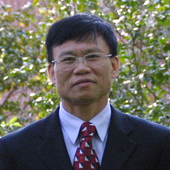
Zhong-Ren Peng
Professor; Director, International Center for Adaptation Planning and Design
Email: zpeng@ufl.edu
Urban Planning AI, transportation and land use, information technology for planning, climate adaptation, GIS, and sustainable urban systems.

Emre Tepe
Associate Professor
Email: emretepe@ufl.edu
Urban analytics, spatial econometrics, land use change, spatiotemporal modeling, machine learning, artificial intelligence, and big data.

Shenhao Wang
Assistant Professor; Director, Urban AI Laboratory
Email: shenhaowang@ufl.edu
Urban science, deep learning, choice modeling, urban mobility, network analysis, computational urban justice, and generative AI for planning.

Yan Wang
Associate Professor; Founder and Director, Urban Agility and Resilience Lab
Email: yanw@ufl.edu
Urban resilience, urban analytics, responsible AI, crisis informatics, spatial and infrastructure planning, and smart and connected communities.

Zhaoxi Zhang
Assistant Professor; Lead, U.TOP Lab
Email: zhang.zhaoxi@ufl.edu
Urban health sensing, participatory AI, human-computer-environment interaction, 3D simulation, urban robotics, and technology-forward urban design methods.

Vivian Wong
Assistant Professor
Email: vivian.wong@ufl.edu
Spatiotemporal analysis, machine learning, computer vision, human mobility, urban infrastructure, and simulation of operations and logistics.
Frequently Asked Questions
Common questions about academic background, curriculum pathways, applications, and career direction.