
RESILIENT Cedar key
Vulnerability Assessment and Adaptation Plan
Reimagining Cedar Key’s future through vulnerability assessment, community engagement, and adaptation planning for long-term coastal resiliency, including a new civic center, adaptive housing, and community-centered urban design.

Cedar Key is a historic coastal community located on the Nature Coast in Florida’s Gulf of Mexico. Despite its small population, the city remains a relevant regional location due to its historic, cultural, economic, and ecological value. Shaped by coastal economic activities, transportation, and the old Florida Railroad, Cedar Key today supports thriving aquaculture, coastal tourism, and environmental research.
However, its low-lying coastal setting and close relationship with the surrounding environment also create increasing challenges from flooding and future climate impacts, emphasizing the need to better understand vulnerabilities and plan for long-term adaptation.
Florida’s Gulf Coast faces increasing climate risks from sea level rise, stronger storms, and coastal flooding. Due to its low-lying topography and direct exposure to the Gulf of Mexico, Cedar Key is particularly vulnerable to these impacts. Rising water levels, shoreline erosion, and aging infrastructure continue to create challenges for transportation networks, utilities, homes, businesses, and the aquaculture industry that supports the local economy.
Recognizing these growing risks, the City of Cedar Key partnered with the University of Florida to develop a comprehensive Vulnerability Assessment and Adaptation Plan. The study evaluates future climate exposure, identifies vulnerable community assets and infrastructure, and provides data-driven strategies to guide long-term adaptation, strengthen resilience, and support sustainable decision-making.
What is the Study About?
Resilient Cedar Key is a multiyear collaboration with the City of Cedar Key that supports the community in adapting to climate-related challenges while preserving its historic character and economic activity. This initiative began with a comprehensive Flood Vulnerability Assessment that identifies climate risks, evaluates impacts on critical assets, and includes an actionable Adaptation Plan outlining practical strategies to enhance resilience across Cedar Key. Using innovative digital tools for community participation and translating public policy into a spatial framework for adaptation, the study envisions flood resilience as a resource to preserve and enhance Cedar Key’s spatial qualities.
Vulnerability Assessment

Adaptation Plan

Vulnerability Assessment
Evaluates exposure and sensitivity of critical assets to rainfall, tidal, and storm surge flooding.
Study Area
Structured around its complex geography and hydrologic connections, the study area is organized into six zones, each with distinct districts and community characteristics.

Critical Asset Categories
Transportation
Transportation vulnerability is concentrated along access the road from the mainland and key corridors throughout Cedar Key. Flooding along these vital connections threatens emergency response, daily mobility, and access to essential services.

Click the map to enlarge.
Housing
Housing vulnerability occurs generally in low-lying residential areas and along the shorelines. Most of this assets are vulnerable to a Category 1 storm event.

Click the map to enlarge.
Critical Infrastucture
A category 1 storm will heavily impact most of the community and emergency facilities. Assets at risk include the school’s western access, main pedestrian tourist and restaurant areas, post office, library, city hall, fire station, and food pantry.

Click the map to enlarge.
Community Emergency
Community and emergency facilities are concentrated in areas with increasing flood exposure, placing essential public services at greater risk during future coastal hazards. Reducing flood impacts is to ensuring uninterrupted emergency response, public services, and community support.

Click the map to enlarge.
Natural & Cultural Resources
Natural and cultural resources will experience a stark increase in flood exposure over time, with any extreme water level event affecting all the parks or recreational areas.

Click the map to enlarge.
Local Economy
As tidal flooding intensifies, most of Cedar Key’s economic assets, including the shops, restaurants, and tourist spaces in the historic core, will be at high risk. The tourist area along Dock Street is highly vulnerable to moderate storm-surge events, such as a Category 1 hurricane.

Click the map to enlarge.
Compound Vulnerability
The Compound Vulnerability Assessment synthesizes results from all critical asset categories to identify where multiple risks overlap across Cedar Key. The assessment highlights four priority areas that will guide future adaptation strategies and resilience investments.
Focus Area 1 – Downtown Cedar Key
Highest overall vulnerability across community assets, critical infrastructure, transportation, community facilities, and businesses.
Focus Area 2 – Mid Cedar Key
Combined vulnerabilities across housing, critical infrastructure, natural resources, and, most importantly, transportation connectivity.
Focus Area 3 – West Cedar Key
Primary vulnerabilities in residential areas, natural resources, and transportation access.
Focus Area 4 – North Cedar Key
Vulnerabilities centered on transportation connectivity to the mainland, housing, and local economy assets.

Adaptation Plan
Defines and prioritizes actions to reduce vulnerability, protect critical assets, and guide long-term adaptation strategies.
Adaptation Focus by Zone
Building on exposure and sensitivity analyses, the adaptation focus by zone identifies zone-specific vulnerability dynamics, guides the identification and goals of individual adaptation actions, and defines a framework for an integrated resilience system.
Zone 1, Downtown
Connect and Redevelop
Relocate essential services and create a new housing offer on higher ground in West Downtown. Ensure transportation connectivity to the marina.

Click the map to enlarge.
Zone 2, Mid
Hydrologic Connectivity
Restore hydrologic connectivity and re-establish natural floodways while securing critical transportation access to the West District.

Click the map to enlarge.
Zone 3, West
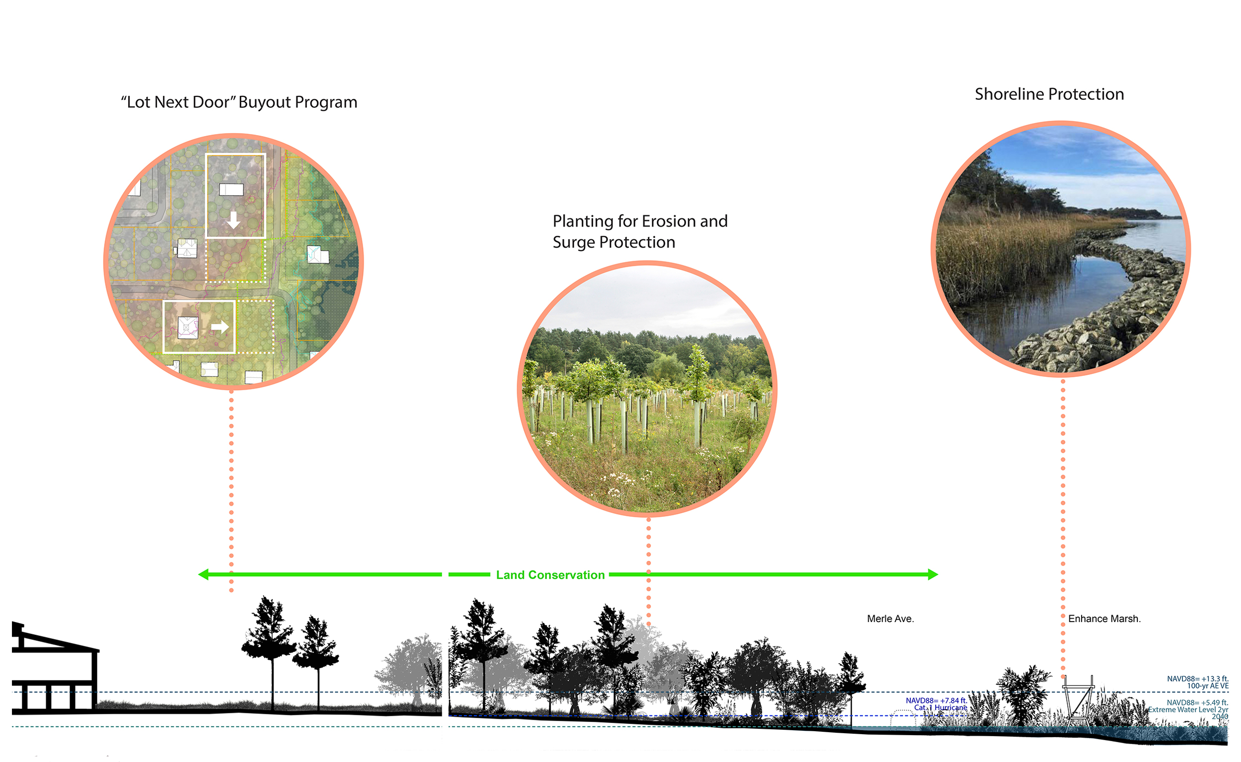
Land Conservation
Preserve undeveloped land to enhance natural habitats and enforce stricter environmental rules for development.

Click the map to enlarge.
Zone 4, North
Local and Bypass
Alternative bridge access and enhance existing City access as a local industry corridor.

Click the map to enlarge.
Zone 5, South
Airport and Shoreline Protection
Shoreline protection and road retrofits to safeguard airport access and functionality.

Click the map to enlarge.
Zone 6, Influence Area
Protect and Plug-in
Limit development in the inland neighboring areas and connect Cedar Key to the inland utility networks.

Click the map to enlarge.
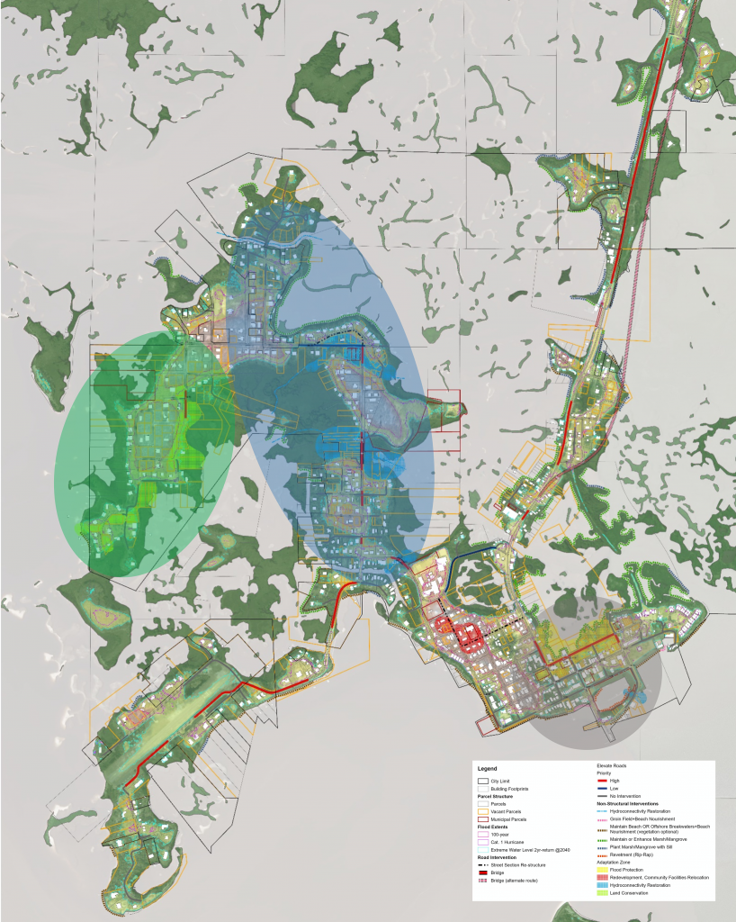
Adaptation Plan Spatial Framework
The Spatial Framework provides a comprehensive vision for implementing adaptation strategies across Cedar Key. It maps proposed actions and their spatial relationships, organizing them into Adaptation Project Areas, each aligned with a core focus to guide long-term resilience planning:



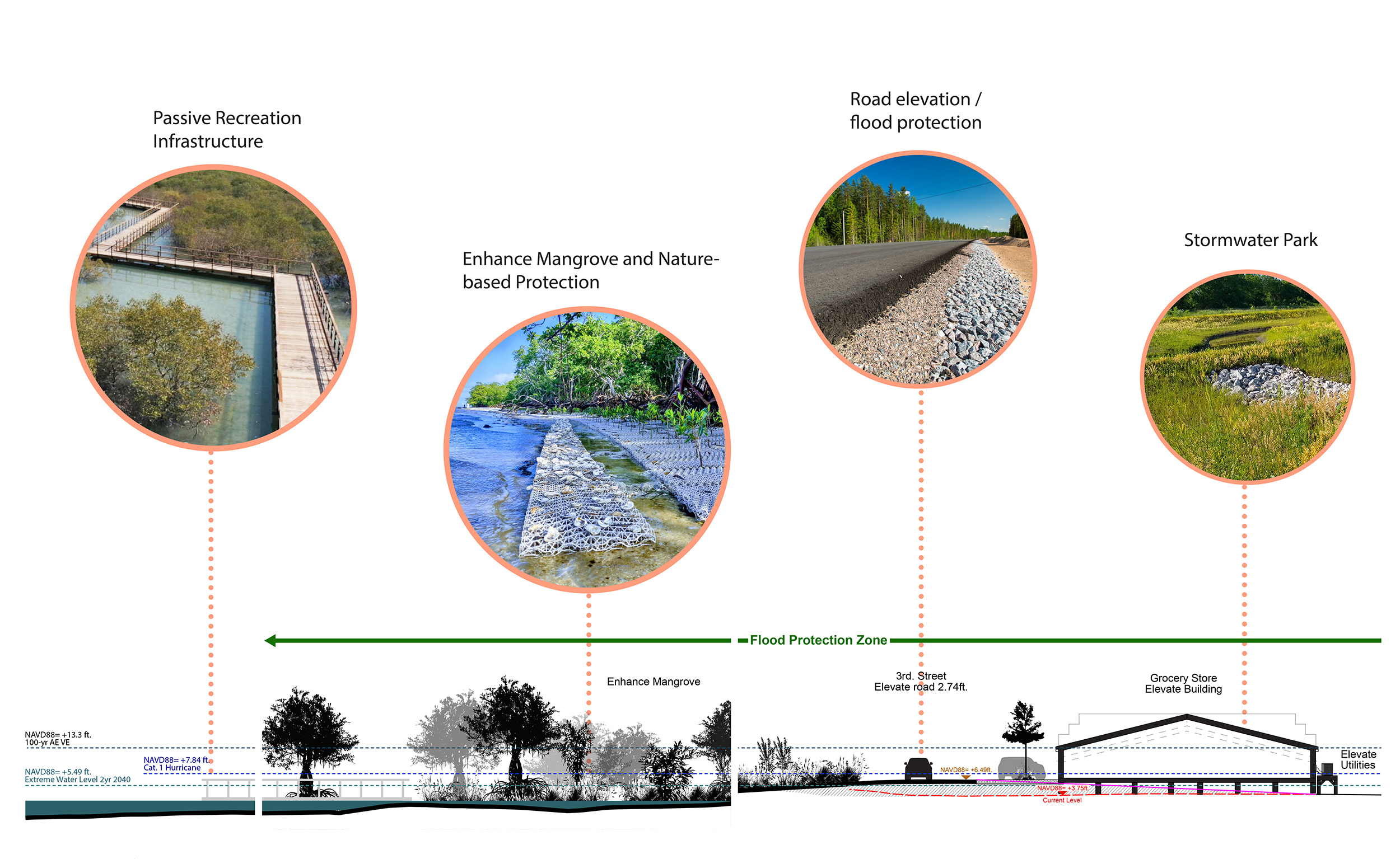
PROJECT AREA 1: transportation Infrastructure

Future sea-level rise threatens access to eastern Downtown, a vital infrastructure hub for Cedar Key’s clam industry and water-based economy.
Elevating 3rd and D Streets secures long-term connectivity to this vital economic area. Integrated into the project, a restored, publicly accessible mangrove area mitigates storm surge and creates a public amenity.


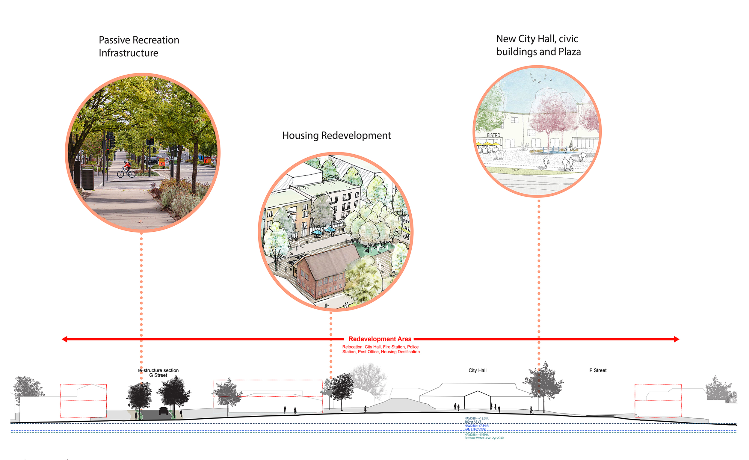
PROJECT AREA 2: A NEW CIVIC CENTER

Most of the community facilities and services in the historic core are flood vulnerable during moderate storms and should be elevated or relocated to a safer area. This project involves relocating these facilities to the higher ground area around the new City Hall. It also includes a mixed-use redevelopment, modern affordable housing, and public space improvements.


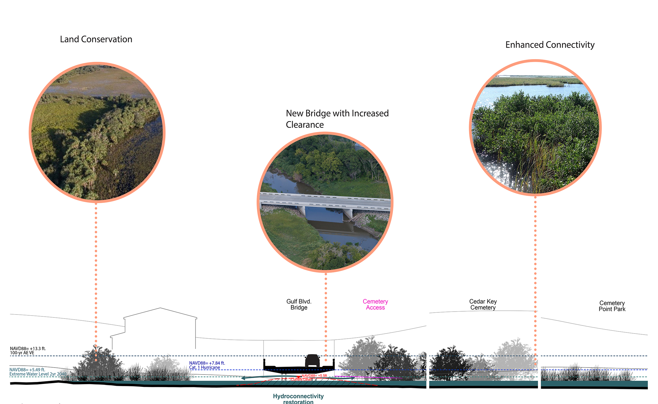
PROJECT AREA 3: HYDROLOGIC RESTORATION AND INFRASTRUCTURE

The Cedar Key archipelago geography naturally allows floodwaters to flow through the system rather than deflect them around built structures. This project restores water connection and natural flood areas at three vulnerable locations. Road retrofits enable restoration of hydrologic connectivity while ensuring accessibility to the western part of own during moderate flood events.


PROJECT AREA 4: WEST CEDAR KEY

Much of West Cedar Key is low-lying and low-density, making small-scale land conservation efforts necessary to reduce flood risks. This project encourages strategic land acquisition by homeowners to promote land conservation and expanded participation in the Community Rating System (CRS) program to limit future development in vulnerable areas.


Project Outcomes & Reports
Vulnerability Assessment Report

Adaptation Plan
Report

Resilient Cedar Key Web App

Explore the Cedar Key Dashboard to interact with flood scenarios, visualize the impacts of compound flooding across multiple storm events and sea-level rise scenarios, and explore critical community assets through dynamic maps and interactive data visualization.