
RESILIENT PORT ST. JOE
Vulnerability Assessment and Adaptation Plan
Combining a comprehensive, community-directed flood risk assessment with spatial strategies that protect vital infrastructure and enhance community spaces.

Built in collaboration with its residents, the Resilient Port St. Joe Vulnerability Assessment and Adaptation Plan develops a data-driven, spatial analysis process to evaluate the potential effects of sea-level rise and storm surge across community critical assets. Beyond a list of individual measures, the plan provides a spatial framework for comprehensive adaptation of city areas, driving long-term resilience while enhancing their existing qualities.
Understanding Flood Hazards Dynamics
Port St. Joe faces growing exposure to tidal flooding, sea level rise, storm surge, and stormwater. Moving beyond flood quantification, understanding the spatial hazard dynamics, including how flooding impacts neighborhoods, where infrastructure risk concentrates, and potential effects on economic activity, is essential. This analysis grounds a holistic approach to adaptation that connects infrastructure measures with the town’s urban and social dimensions.
Building a Resilience Roadmap
The Adaptation Plan defines actions, prioritizes, and sequences resilience investments across short- to long-term planning horizons. Taking a spatial approach, the plan defines relational conditions for adaptation actions, moving from localized interventions to systemic resilience, while guiding spatial planning policy for low-risk urban development.
Vulnerability Assessement

Adaptation Plan

vulnerability Assessment
Evaluates the exposure and sensitivity of critical assets to rainfall, tidal, and storm surge flooding.
Area of Interest and Analysis Zones
The Area of Interest is structured into distinct zones based on Port St. Joe’s specific spatial characteristics, including geography, urban form, land use, density, and elevation. This differentiation enables a place-based approach to identify vulnerabilities and potential adaptation strategies. The study area has been organized into six zones:
Zone 1 – Downtown Port St. Joe
Compact urban form at the historical core. Large open areas connected to the shoreline. Mostly non-housing uses.
Zone 2 – North Port St. Joe
Elevated residential area between the railroads. Large industrial and critical infrastructure.
Zone 3 – South Port St. Joe
High elevation areas on both sides of Chicken House Creek, areas in development process.
Zone 4 – East Port St. Joe
East side of Central Channel, high elevation area mostly residential. Favorable connectivity to evacuation routes.
Zone 5 – West Port St. Joe
Low-lying area, highest amount of residence buildings. Location between St. Joseph Bay and Central Channel
Zone 6 – Beach Communities
Influence Area, not a specific zone but includes the surrounding region containing critical assets that influence the functioning of Port St. Joe

Critical Asset Categories, Exposure Analysis Highlights
Housing Exposure Analysis
Housing vulnerability is projected to increase significantly over time, with Category 2 hurricanes becoming a major driver of residential flood exposure. Approximately 30% of homes could be affected by 2040, increasing to nearly 50% by 2070.

Click the map to enlarge.
Transportation Exposure Analysis
Transportation networks become increasingly vulnerable under storm surge scenarios. A Category 2 hurricane could flood nearly 80% of roads in Downtown and West Port St. Joe, limiting access to key corridors and disrupting connectivity throughout the city.

Click the map to enlarge.
Critical Infrastucture Exposure Analysis
Critical infrastructure is projected to face substantially greater flood exposure under future storm scenarios. By 2040, a Category 2 hurricane could affect more than 30% of critical infrastructure assets, increasing to over 50% by 2070, while stronger storms may expose essential facilities to significant flood depths.

Click the map to enlarge.
Community and Emergency Facilities Exposure Analysis
Community and emergency facilities are projected to experience increasing flood exposure under future storm scenarios. By 2070, a Category 2 hurricane could affect nearly three times as many facilities as today, with the greatest impacts concentrated in the Downtown area.

Click the map to enlarge.
Natural, Cultural, and Historical Resources Exposure Analysis
Natural, cultural, and historical resources represent some of Port St. Joe’s most vulnerable assets. By 2040, a Category 2 hurricane could inundate many historic structures, parks, and open spaces, highlighting the importance of protecting the city’s environmental and cultural heritage.

Click the map to enlarge.
PSJ Beach Communities Exposure Analysis
The Beach Communities are among the areas most exposed to coastal flooding due to their low elevation and proximity to the Gulf. Future hurricane scenarios indicate increasing risks to housing, transportation, infrastructure, and beach access, with widespread flooding expected during Category 2 and stronger storms.

Click the map to enlarge.
Compound Vulnerability and
Focus Areas
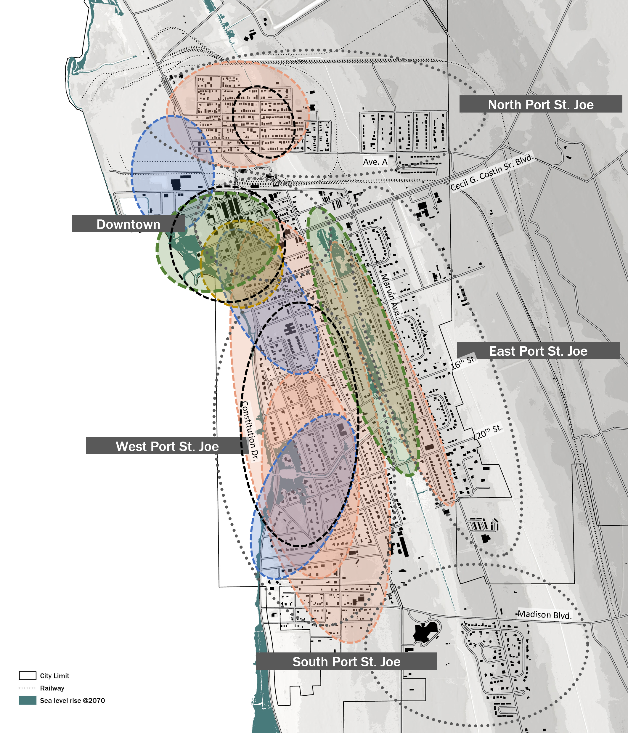
The Compound Vulnerability Map synthesizes exposure analysis results across all critical asset categories to identify where multiple risks overlap throughout Port St. Joe. The assessment highlights five priority areas that will guide adaptation strategies and prioritize resilience investments.
Based on this analysis, five priority adaptation areas were identified across Port St. Joe. These focus areas represent locations where targeted investments, infrastructure improvements, and resilience strategies can reduce future flood impacts while supporting sustainable community development. Community feedback was also incorporated to ensure the identified priorities reflect local conditions and planning needs.

Adaptation Plan
The vulnerability assessment synthesizes flood exposure across multiple asset categories to identify where risks overlap throughout Port St. Joe. These findings identify priority areas where targeted resilience strategies and future investments can have the greatest community impact.
Adaptation Zones
The following focus areas present targeted adaptation strategies developed from the Vulnerability Assessment. By addressing the specific challenges and opportunities within each area, the Adaptation Plan provides a framework for reducing flood risk, strengthening community resilience, and guiding future investments across Port St. Joe. The plan is guided by three core principles: highlighting the city’s hydrologic conditions, ensuring transportation connectivity, and enhancing flood resilience through place-based solutions that respond to local needs.

To support effective implementation, the Adaptation Plan organizes the city into six adaptation zones—Downtown Port St. Joe, North Port St. Joe, South Port St. Joe, East Port St. Joe, West Port St. Joe, and the Beach Communities. Each zone reflects distinct geographic, environmental, and community characteristics, allowing tailored adaptation strategies that address local priorities while contributing to a more resilient and connected Port St. Joe.
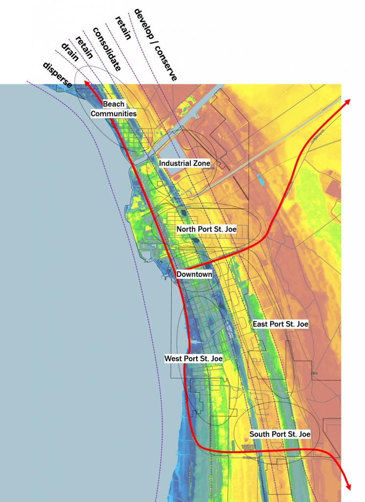
The following projects illustrate key adaptation plans and its primary focus areas:
Project 1:
Disperse Zone
George Core Park and Historic Core: Focus on storm surge protection.
Project 2:
Retain Zone
Central Channel: Increase retention capacity and restore wetlands.
Project 3:
Drain Zone
Battles Street: Enhance surface drainage and create open space.
Project 4:
Consolidate Zone
Civic Center: Housing development and urban development.


Stormsurge Buffer
Lighthouse Park

Disperse
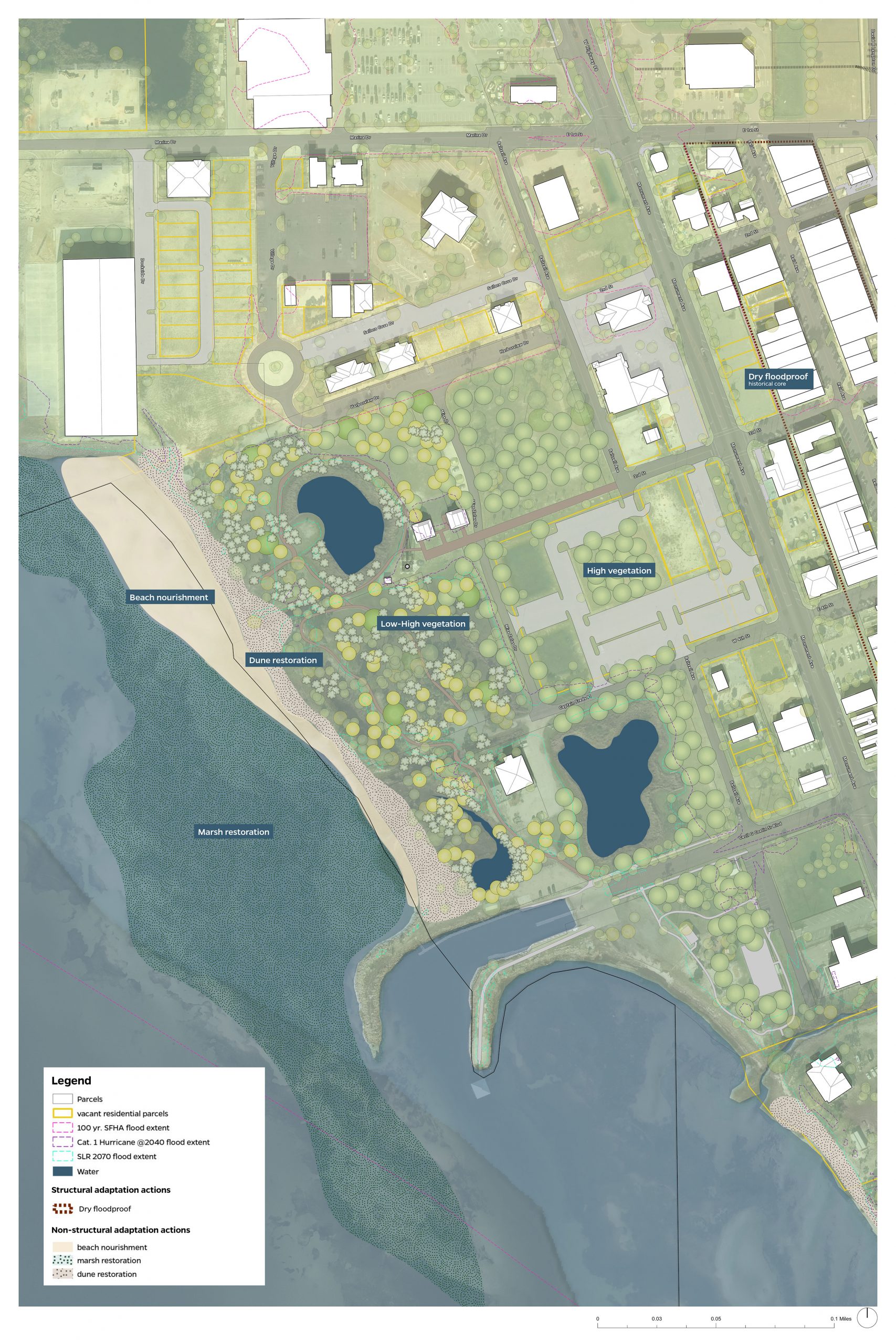
In anticipation of rising sea levels and the heightened risk of hurricanes over the next 50+ years, formulating a strategic plan for downtown Port St. Joe involves establishing a series of protective buffer layers. These layers are designed to both effectively manage water and mitigate the impact of storms. The plan encompasses various elements, such as coastal wetlands along the beach edge, restoration of the historic beach area through nourishment, dune rehabilitation, incorporation of native plants and trees, and the installation of flood barriers.
By combining nature-based solutions, engineering interventions, and temporary measures, this comprehensive system is seamlessly integrated into the existing landscape and topography. These features not only offer crucial protection to the citizens of Port St. Joe but also provide recreational amenities. Additionally, this integrated approach has the potential to enhance the utilization of Lighthouse Park.


Retention Infrastructure
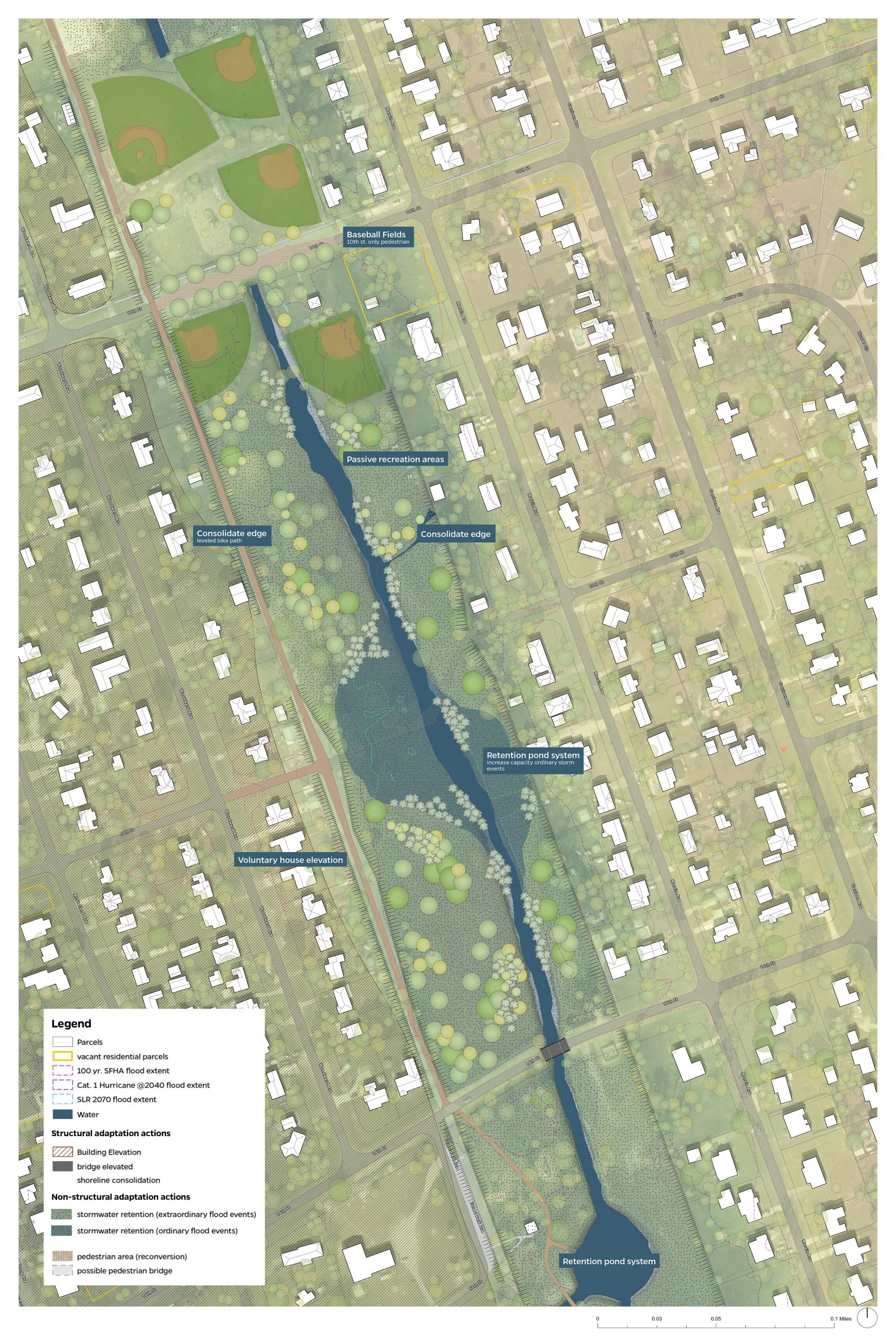
Central Channel Retention Park

A Retention System
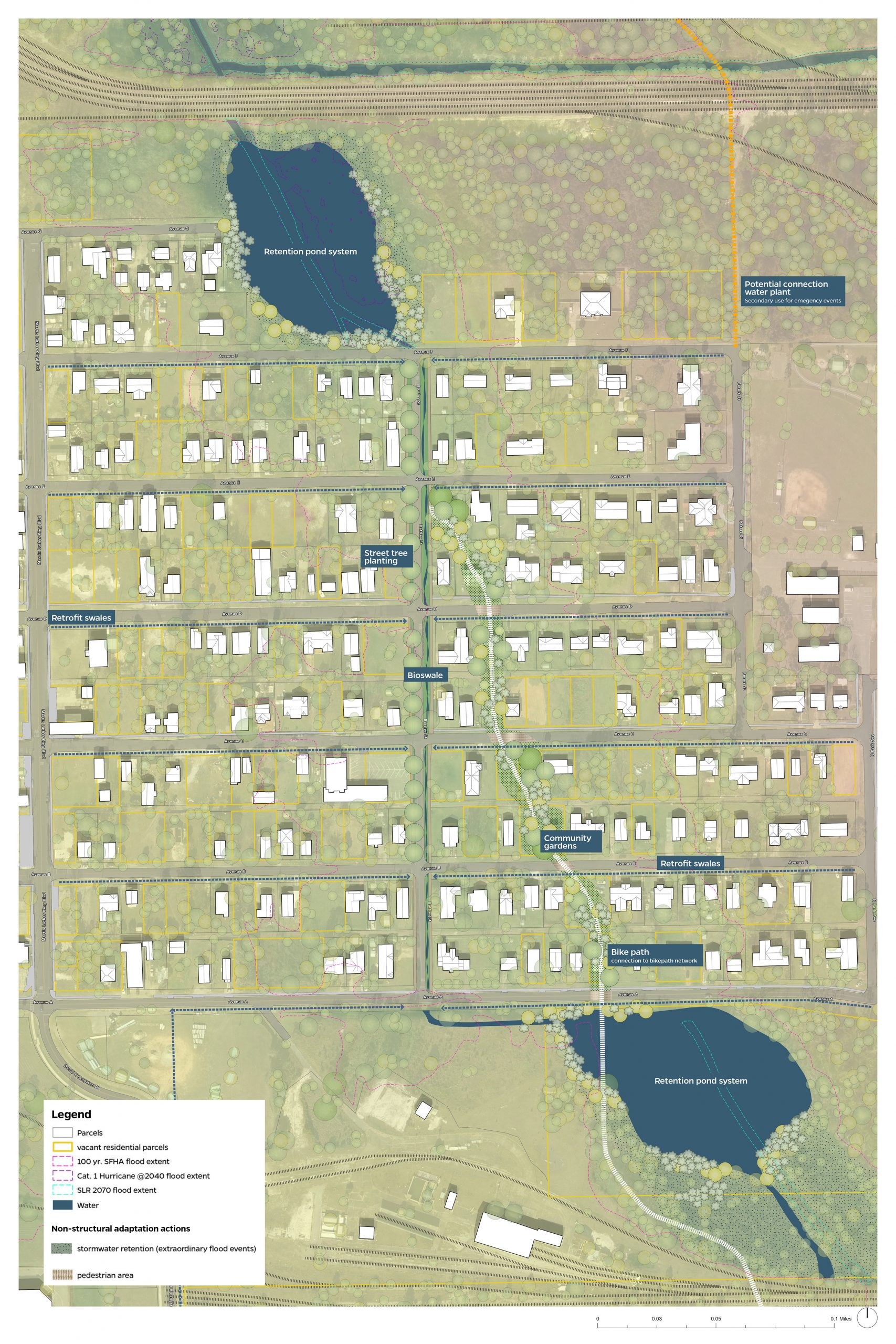
Central Channel cuts through a long strip that is lower in elevation compared to the houses next to it. Connecting retention ponds and adding vegetation will help manage flooding by holding and draining water that will naturally flow from the built areas into the channel. This project will also provide a public amenity for residents, with vegetated areas, walking trails, and a bike path.


Connect and Drain
Battles St. Bioswale, Bikepath & Urban Agriculture

Drain
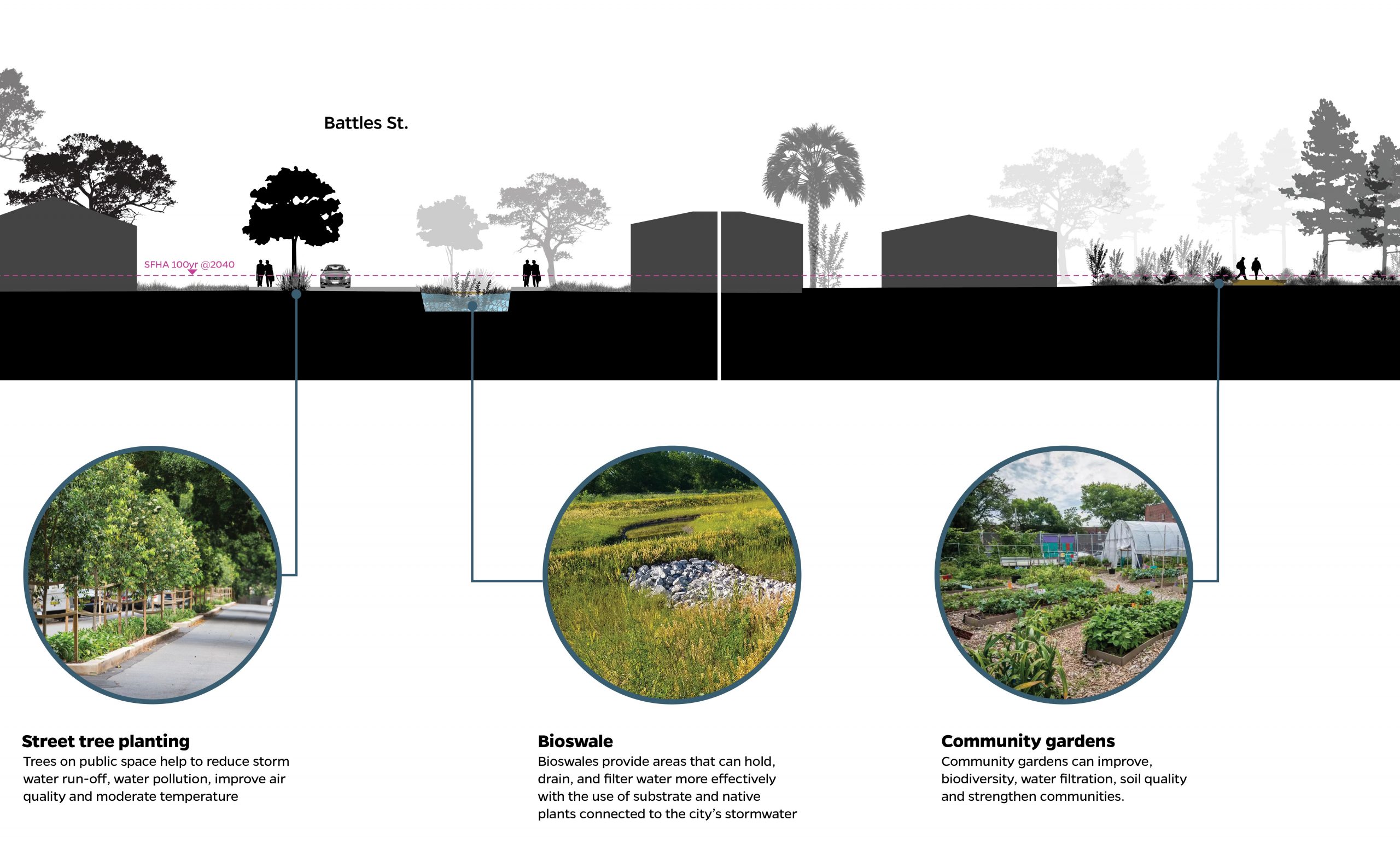
Low-lying areas that were once prone to water accumulation, but have since been filled in, present excellent opportunities for implementing bioswales and effective drainage solutions. These locations are linked to a broader network of canals and marshlands that naturally retain and regulate water from developed areas. Integrating a recreational space with a resilient drainage system not only safeguards the surrounding neighborhood but also provides a valuable public amenity. Bioswales, as part of an integrated drainage system, incorporate native plants and underground stormwater drains to enhance their effectiveness.

Consolidate and Conserve
PSJ Civic Center and Updates

Consolidate
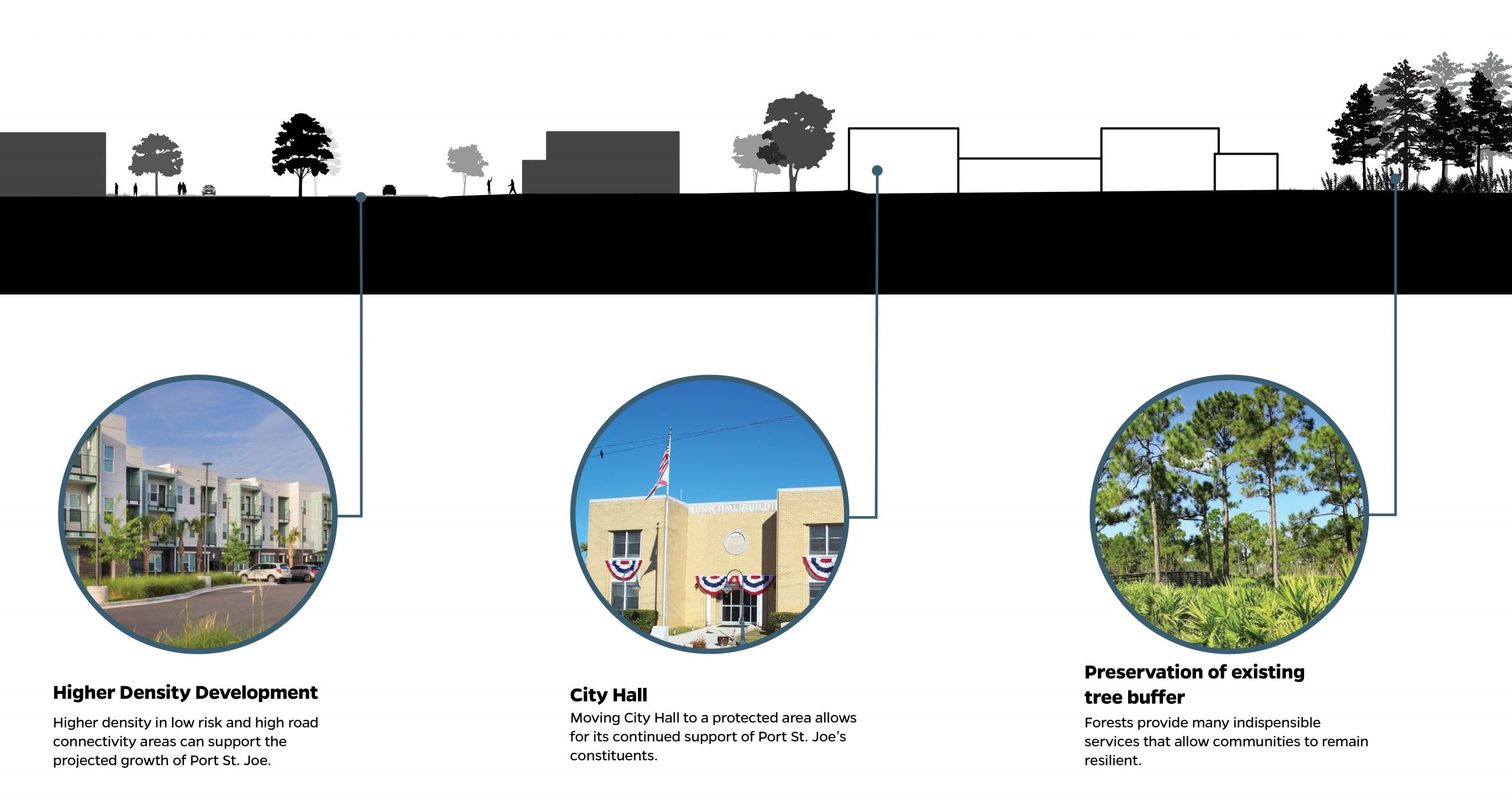
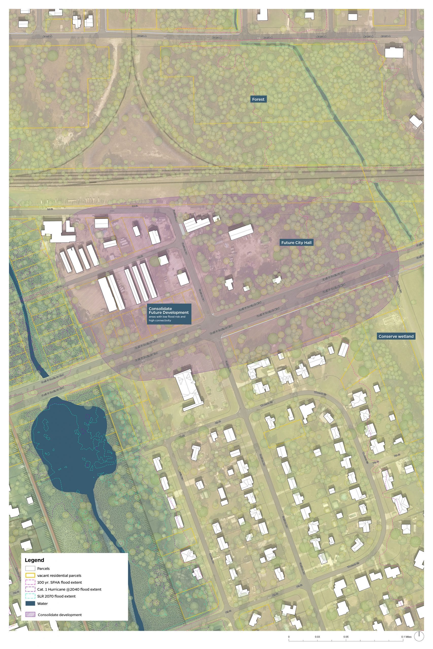
Port St. Joe anticipates sustained population growth and increased housing demand. Concentrating this growth offers multiple advantages, such as enhanced protection against storms and improved efficiency in delivering essential services like power, water, and sewer. The elevated terrain in Port St. Joe provides a conducive environment for more compact development, minimizing vulnerability to flooding.
Relocating City Hall to a protected zone not only ensures improved accessibility to essential resources for all citizens but also reduces maintenance and potential damage repair costs. Additionally, preserving the densely forested area at the city’s rear is crucial for maintaining the natural ecosystem that spans the city. This preservation contributes to ongoing services provided by the forest, including temperature regulation, water management, and acting as a buffer against storms.

Project Outcomes & Reports
Resilient Port St. Joe: Vulnerability + Sensitivity Analysis Report

Resilient Port St. Joe:
Adaptation Plan
