
Matlacha Pine Island Road, Urban Resilience Strategy
Reimagining Pine Island Road to support recovery, strengthen public space, and build long-term resilience in the face of recurring flooding.
The Matlacha Pine Island Road Public Space and Parking Urban Strategy focuses on addressing two interconnected challenges faced by the Matlacha community: recovery from recent hurricane-related flood events and preparation for long-term climate resilience. Pine Island Road is the only road connecting Matlacha to the mainland and is the heart of the town’s businesses and everyday activity.
This project aims on rethinking how public space, parking, and movement along the corridor can be reorganized to better support recovery, improve accessibility, and strengthen the role of Pine Island Road as a functional and resilient main street, while responding to increasing environmental risks.
Pine Island Road is not only a critical transportation corridor connecting Pine Island, Matlacha, and the mainland, but also the spatial and commercial heart of the town’s historic core. Its narrow right-of-way, limited parking, and close proximity between vehicles and pedestrians create ongoing safety and mobility challenges that are intensified during peak traffic periods and public events.
Following recent hurricane seasons, flood damage to buildings, business closures, and disrupted economic activity have heightened community concerns about the corridor’s long-term functionality and resilience. Recovery efforts often focus on restoring pre-hurricane conditions, yet recurring flood risks call for a more comprehensive approach that integrates public space, infrastructure, and land use to support a safer, more vibrant, and adaptable coastal community.
This project explores a set of urban resilience scenarios that integrate flood adaptation strategies with urban design and planning principles. Building on an analysis of existing physical conditions, including transportation infrastructure, land use patterns, parking demand, and baseline flood scenarios. The study develops alternative approaches for public space design, parking organization, and redevelopment along Pine Island Road.
The scenarios respond to varying spatial conditions along the corridor and are designed to support local businesses, enhance pedestrian safety, improve mobility, and accommodate future flood conditions. As part of the broader Pine Island & Matlacha Resilience Strategy, these scenarios aim to inform dialogue with community members and institutional partners, identify implementation pathways, and establish a shared foundation for future planning and investment.
Urban Resilience Scenarios
The following scenarios explore alternative design approaches for public space, mobility, parking, and redevelopment along Pine Island Road under varying flood conditions.


SCENARIO 1:
Tactical Urbanism
Scenario 1: Tactical Urbanism introduces simple, low-cost, and temporary improvements along Pine Island Road without changing the existing infrastructure. It uses elements such as pavement art, movable barriers, and planters to improve safety, organize space, and support local businesses. This flexible approach allows the community to test ideas before committing to permanent changes.
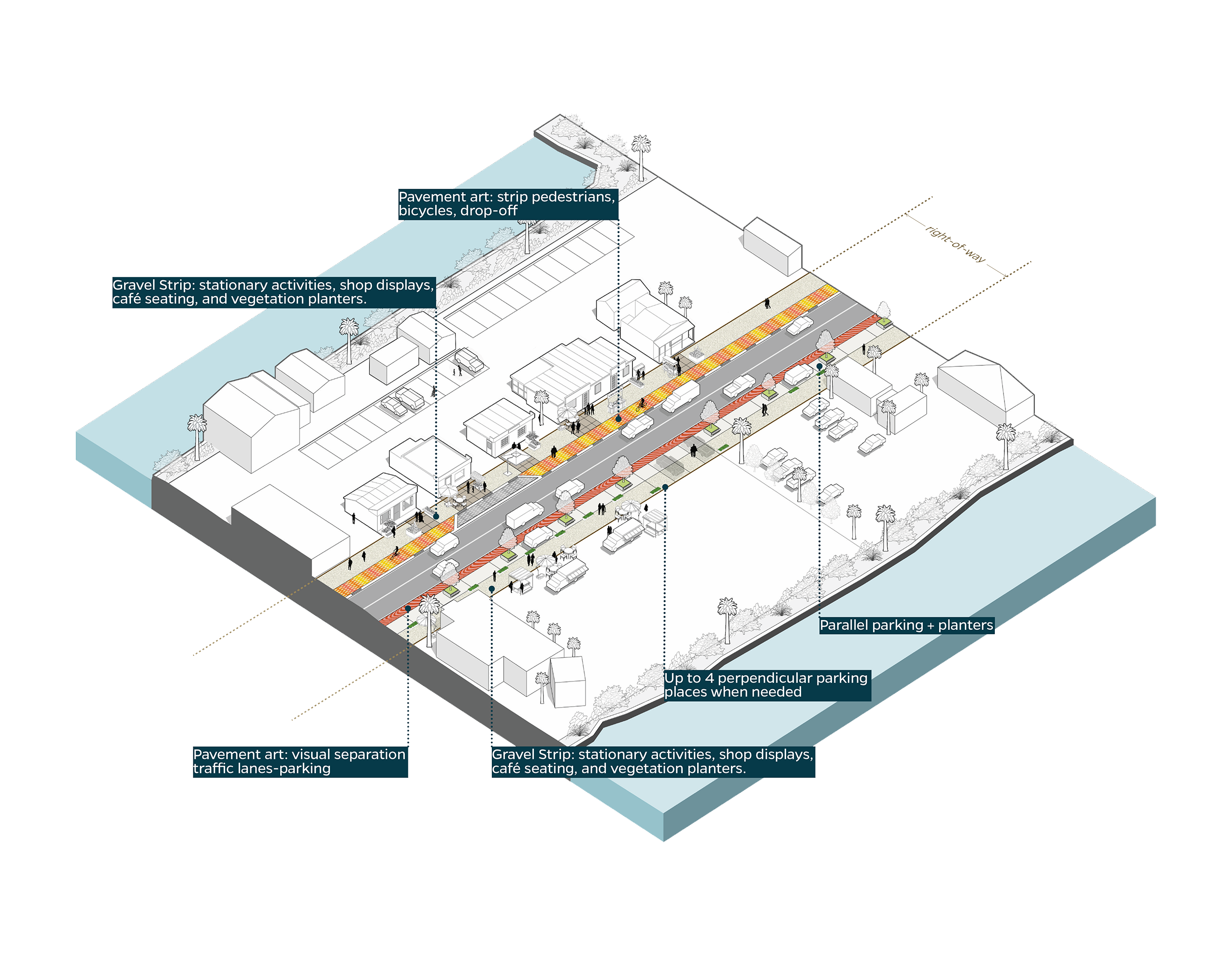
Scenario 1. Evaluation of benefits and trade-offs


SCENARIO 2:
Big Deck. Tidal Flooding Resilience
Scenario 2: Elevated “Big Deck” Adaptation introduces a coordinated flood adaptation strategy through a shared elevated platform designed to withstand frequent tidal flooding. Raised above existing ground levels, the platform creates a safer area for daily commercial and public activities.
It supports flexible uses such as mobile shops, outdoor seating, and gathering spaces, while allowing temporary elements to be relocated during extreme weather events. The design also enhances walkability, organizes parking behind the platform, and integrates green infrastructure to manage stormwater and improve the waterfront environment.
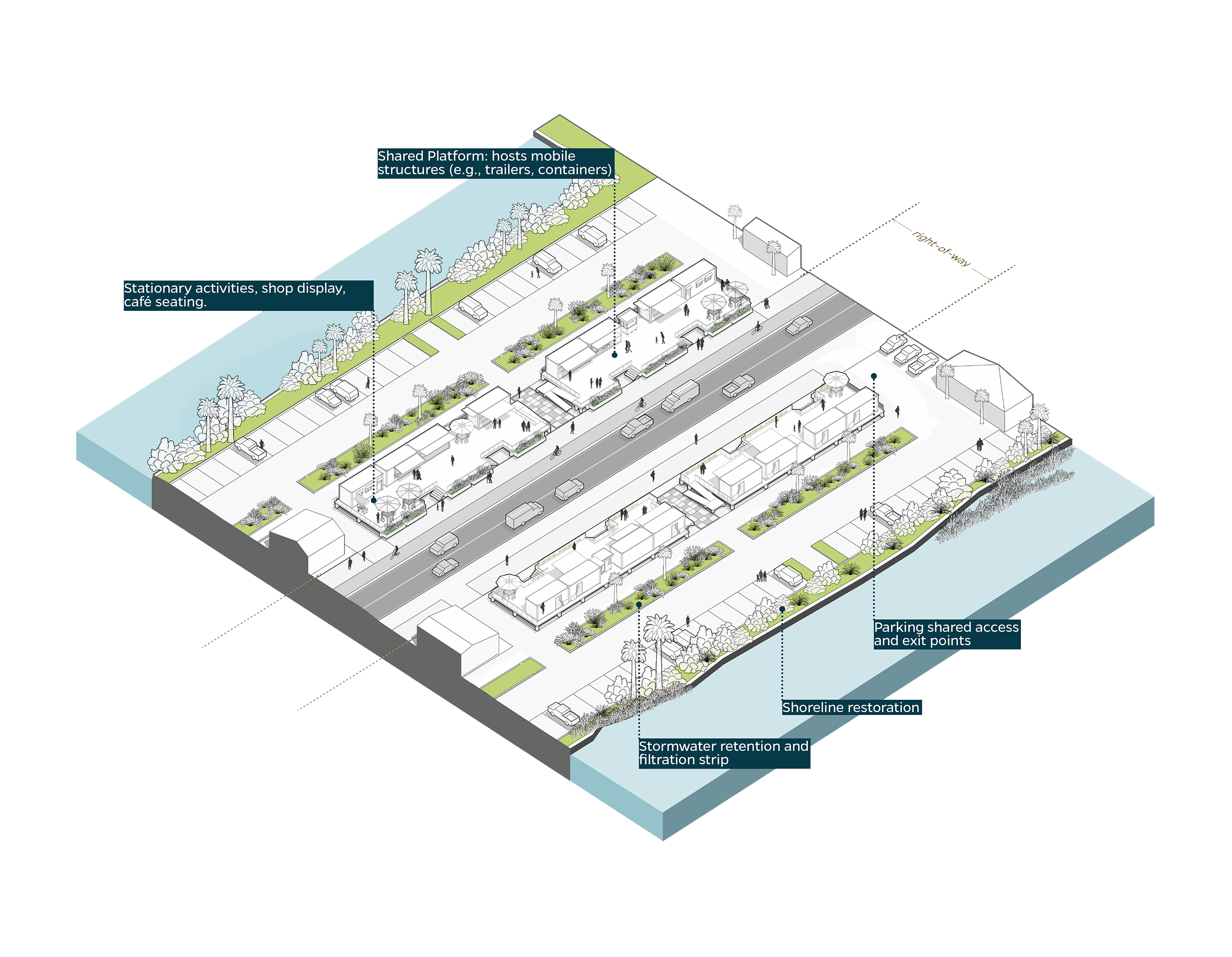
Scenario 2. Evaluation of benefits and trade-offs

Scenario 2 – Big Deck, Land Development & Parking Strategy Pine Island Road. Sections 2 and 3

Scenario 2 – Big Deck, Land Development & Parking Strategy Pine Island Road. Matlacha Historic Core. Section 2

Section Scenario 2 – Big Deck

SCENARIO 3:
Matlacha Arcades. Storm Surge Resilience
Scenario 3: Elevated Shared Structure proposes a long-term adaptation strategy to address severe flooding and storm surge through elevated buildings and shared infrastructure. Using the 100-year flood level as a baseline, buildings are raised to remain functional during extreme events and support faster recovery.
A shared elevated walkway and vertical circulation system connects commercial spaces, creating an active terrace for circulation, seating, and retail. The design improves pedestrian experience with covered ground-level spaces, organizes parking at the rear, and integrates green infrastructure to manage stormwater and enhance the waterfront environment.
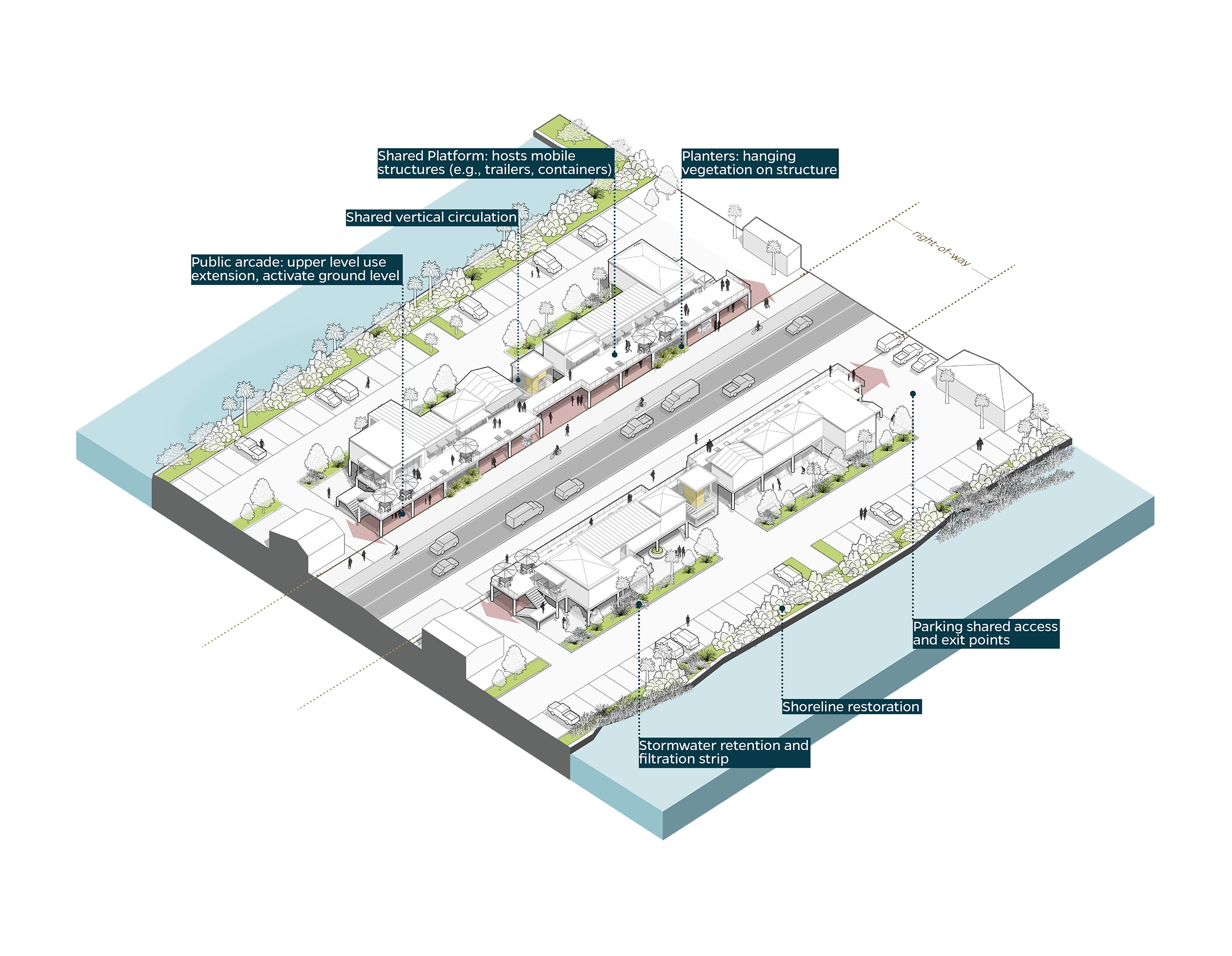
Scenario 3. Evaluation of benefits and trade-offs

Scenario 3 – Matlacha Arcades, Land Development & Parking Strategy Pine Island Road. Sections 2 and 3

Scenario 3 – Matlacha Arcades, Land Development & Parking Strategy Pine Island Road. Matlacha Historic Core. Section 2

Section Scenario 3 – Matlacha Arcades

SCENARIO 4:
Facing Nature. Storm Surge Resilience
Scenario 4: Landscape-Led Adaptation proposes a long-term strategy focused on shoreline restoration and nature-based flood mitigation. Buildings are elevated above flood levels and set back from the street to accommodate green buffers, stormwater filtration, and parking areas.
Elevated structures support permanent commercial uses and are connected by a shared walkway, while the rear of the site is transformed into a landscaped public space that enhances ecological function and reduces flood impacts. This approach prioritizes environmental resilience, though it may reduce street-level activity and connectivity.
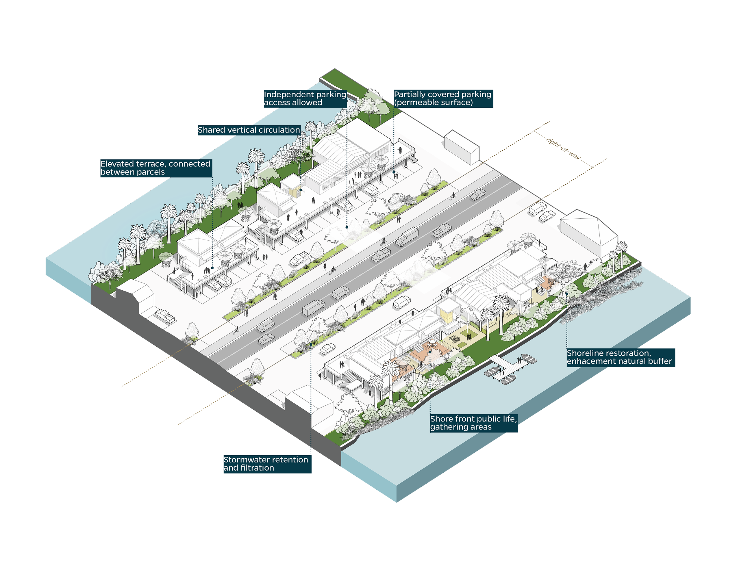
Scenario 4. Evaluation of benefits and trade-offs

Scenario 4–Facing Nature, Land Development & Parking Strategy Pine Island Road. Sections 2 and 3

Scenario 4–Facing Nature, Land Development & Parking Strategy Pine Island Road. Matlacha Historic Core. Section 2

Section Scenario 4 – Facing Nature

Existing Conditions & Flood Planning Analysis
Existing conditions along Pine Island Road—including building use and parking areas—are presented alongside baseline flood planning scenarios to understand current and future flood exposure and to inform the development of urban resilience strategies.
Map Layers Overview
Building use and parking areas
Tidal flooding (MHHW)
Sea level rise 2040 (Intermediate–High)
FEMA 100-year flood
NOAA water level threshold (major disruption)
Flood depth values shown for buildings are calculated above First Floor Height (FFH) to reflect potential impacts to occupied structures.