The Florida Department of Transportation has been maintaining several transportation networks and associated databases, such as the FDOT Work Program (WPA), Roads Characteristics Inventory (RCI), Florida Standard Urban Transportation Model Structure (FSUTMS), Efficient Transportation Decision Making (ETDM) and Florida Geographic Data Library (FGDL). In addition, local government agencies, both cities and MPOs, maintain their own transportation networks and associated databases. These separate databases have accumulated over time and serve their specific applications well. However, data elements from these data sources are useful not only for the application they were originally developed for, but also for other applications such as FSUTMS modeling. In addition to routine duties, there is an increasing need for the state departments of transportation organizations (DOTs) to identify accident locations, conduct real-time mapping, and integrate with other organizations to map business information to a common accurate base map(Kevin Hunt, Brad Hibner (2006). At present, the lack of integration among these different sources impedes the efficient flow of information and exchange of variables among the databases and applications thus limiting the full potential for integrated transportation modeling and environmental analysis. In this situation, to move towards full GIS integration there is a research need to develop a methodology and a set of tools for the integration of a host of information sources into a new database framework. This process is likely to be a very complex exercise fraught with issues related to data formats, data exchange and flow between systems and platforms, consistency in the level of detail, and data updating and maintenance (Transportation Research Board, 1998). Therefore, these databases must be interchangeable, which calls for the creation of a Model Information eXchange System (MIXS).
The Vision of MIXS
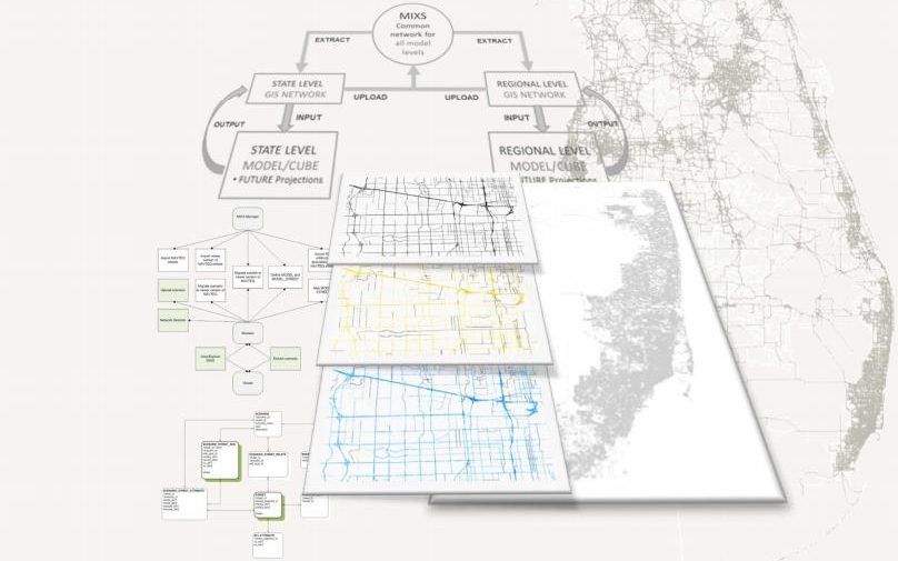
A Model Information eXchange System (MIXS) is a mechanism by which transportation and related data from diverse sources and databases are seamlessly linked, based on common geographic features. The purpose of the MIXS is to facilitate the interaction of information exchange. These databases include WPA, Department Base Map and RCI, Strategic Intermodal System (SIS), ETDM, Transportation modeling (FSUTMS and GIS-TM) and FGDL.
The initial goal of the MIXS is to serve the data needs of the FSUTMS modeling so that these data can be readily available and easily integrated into the FSUTMS models. The ultimate goal of the MIXS, however, is to allow transportation planners, engineers, and other database users to search and extract data from a variety of sources that serve specific applications, without worrying about data models or the data structure of the original source. The MIXS can not only search and extract the data from different sources but also integrate the data on demand by any end-users over the Internet through a user-friendly web interface. Any data update from the original source can be automatically reflected in the MIXS. The MIXS serves as a useful link between existing databases and will therefore serve as a useful tool to those accessing them.